This past spring, March 1 through May 31, was the driest spring in domestic history (Figure 1). The record comes amid plenty of other indicators of unprecedented dehydration. The National Oceanic and Atmospheric Administration (NOAA) reported that January through March 2026 was the driest January-March period hydrologically for the contiguous United States; rain was 30 percent under historical averages. Regionally, the Southeast is suffering the most. Namely, Georgia, North Carolina, and South Carolina experienced record dry conditions through the fall and winter, besting all records since 1895 for the period between September 2025 and March 2026. Half of the country is currently experiencing some kind of drought condition, down from a high of 52.4 percent on April 21, narrowly behind the record tracked by the U.S. Drought Monitor of 54.8 percent set in September 2012 (data dates to 2000).
Figure 1: Spring Drought Conditions in the Contiguous United States, 2022-2026
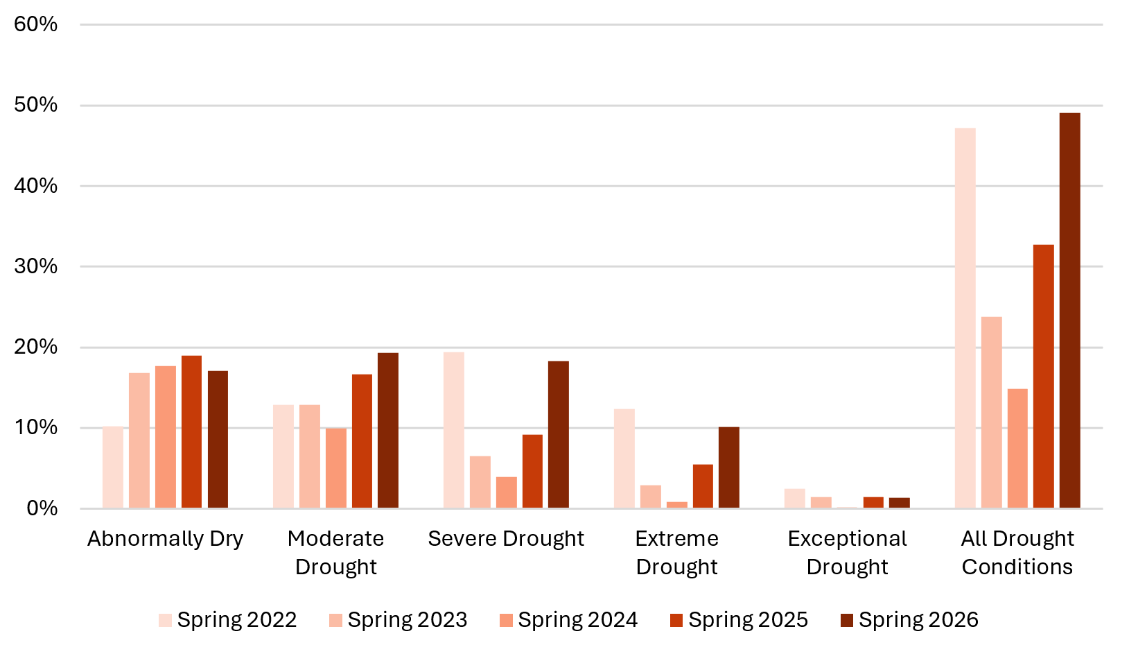
Spring is defined as the meteorological season beginning March 1 and ending May 31.
Source: U.S. Drought Monitor.
Fluctuations in drought conditions are normal and based on a variety of factors, including seasonal variations, when and where rains hit, and weather patterns impacting phenomena such as evapotranspiration. Drought becomes particularly concerning when it is long-lasting and severe. The most recent map from the U.S. Drought Monitor covers data from June 2 through June 9, 2026 (Figure 2). Most of the country is in an abnormally dry condition. A quarter of the country is experiencing normal conditions, while an additional 19 percent is under abnormally dry conditions. Of the remaining 56 percent of the contiguous United States, 21 percent is under moderate drought, 23 percent is under severe drought, 11 percent is under extreme drought, and one percent is experiencing exceptional drought.
Figure 2: Drought Conditions in the United States and Puerto Rico as of June 9, 2026
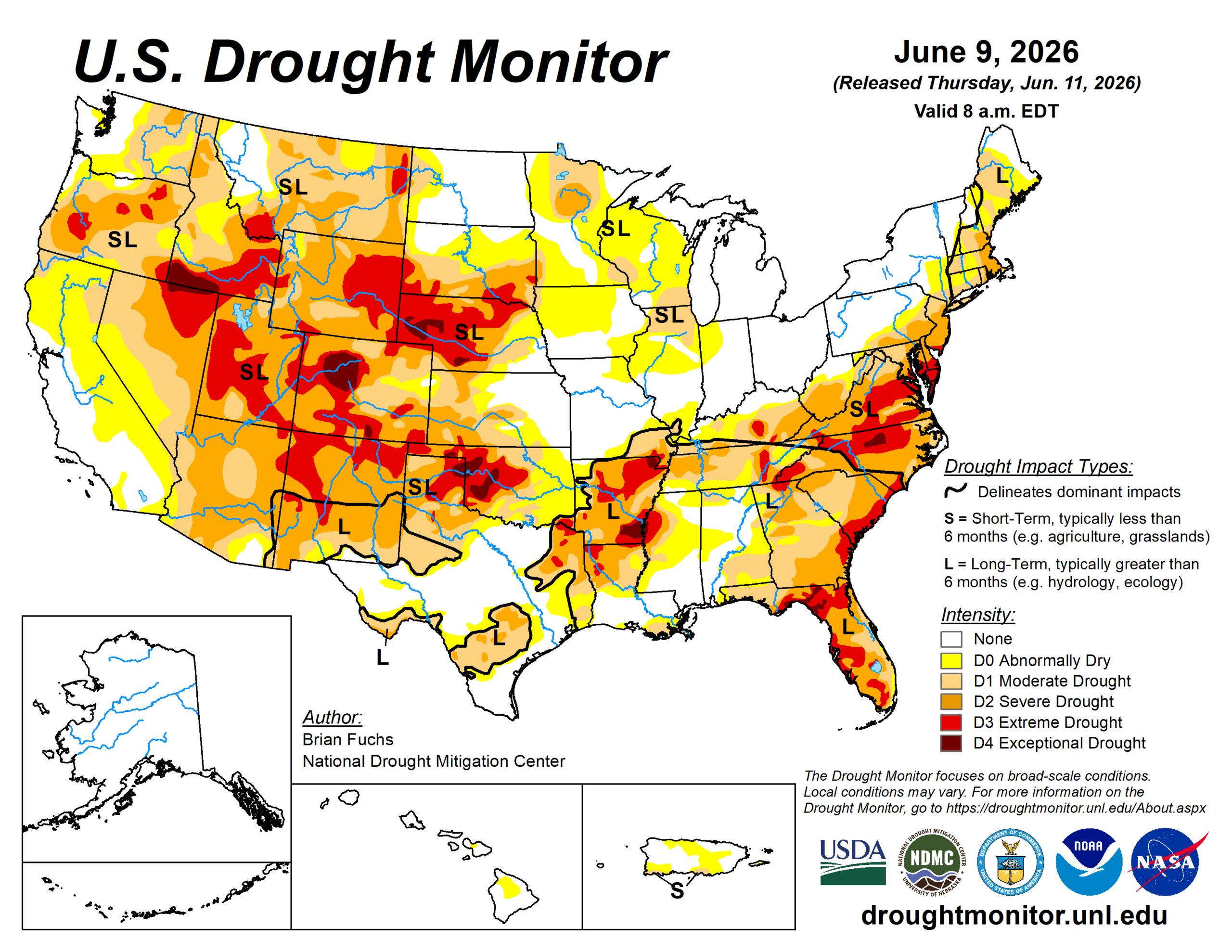
Source: U.S. Drought Monitor.
The U.S. Drought Monitor also analyzes where impacts are likely to linger longer than six months. Greater long-term drought impacts are forecasted to persist in areas marked with Ls, particularly in those areas bounded by bold black lines. Figure 2 highlights that the most severe drought currently being felt is concentrated in the Southeast, the central Plains, and much of the West.
Droughts are experienced differently across the United States. In Florida, wildfires have burned across at least 120,000 acres this year, including significant wetland areas. In the Colorado River Basin, persistent drought has impacted water supply since 2000; however, these conditions are becoming newly critical as water levels at Lake Mead may drop below the volume threshold necessary to generate hydropower. Dryness is also particularly harming domestic agriculture. For instance, late spring is a crucial maturation period for wheat crops in the Great Plains. In the face of the season’s extreme heat, the U.S. Department of Agriculture has estimated that this will be the least productive growing season for the staple since 1966.
A new hydrological disruption arrived in early June. NOAA’s Climate Prediction Center announced that an El Niño has formed in the Pacific and projected a 63 percent chance that the weather pattern would intensify into a Super El Niño between November 2026 and January 2027—one of the largest El Niños since 1950.
Generally, in terms of impacts on the U.S., El Niño events lessen the Atlantic hurricane season and amplifies the Pacific’s. Temperatures will rise across the country and heavier rain showers are expected across the Rockies, the South, and the Southwest—regions currently suffering droughts, per Figure 2. Rains in the South will likely improve agricultural drought conditions. The last El Niño began in the summer of 2023 and raised average global surface temperatures to the extent that the planet broke past the 1.5 degrees Celsius barrier of warming set by the Paris Agreement.